Aerial Surveys
Aerial surveys encompass a range of techniques employing aircraft and modern technology to collect vital information for various applications.

Aerophotogrammetry
Also known as aerophotogrammetry, aerial survey is a method of collecting geomatics or other imagery by means of aerial platforms. Typically the procedure will comprise of covering the desired area according to a pre-calculated flight plan and using a UAV/MAV to take images at pre-determined positions, and then processing images for data extraction.
Discover the Advantages
Non-contact
Data Collection
Photogrammetry allows for non-contact data acquisition. The measurements and mapping are done remotely using photographs, eliminating the need for physical contact with the objects or terrain being studied.
Cost
Effective
Compared to some other surveying and mapping techniques, photogrammetry can be a cost- effective solution. The use of aerial or terrestrial photography reduces the need for expensive equipment or on-site personnel.
Rapid Data
Acquisition
High Spatial
Resolution
With advancements in camera technology, photogrammetry can achieve high spatial resolution. This allows for the capture of fine details in the terrain or objects being surveyed, making it suitable for applications that require high precision.
Flexibility
and Adaptability
Photogrammetry is a versatile technique that can be applied in various environments and for different purposes. It can be used for mapping terrain, creating 3D models of structures, monitoring environmental changes, and more.
3D
Visualization
Photogrammetry provides the capability to create detailed and accurate three-dimensional models
of objects or landscapes. This is valuable in applications such as architecture, archaeology, and
cultural heritage preservation.
Remote
Sensing
Photogrammetry can be employed for remote sensing applications, allowing for the monitoring and
analysis of large geographic areas. This is particularly useful in fields such as agriculture, forestry, and
environmental management.
Integration
with GIS
Photogrammetric data can be easily integrated with GIS for comprehensive spatial analysis. This
integration enhances the capabilities of both photogrammetry and GIS, providing a powerful tool for spatial planning, decision-making, and resource management.
Accessibility
With the availability of consumer-grade drones equipped with high-quality cameras, photogrammetry has become more accessible to a wider range of users. This accessibility has led to increased adoption in fields such as construction, agriculture, and land surveying.
Repeatable and
Historical Comparisons
Photogrammetry allows for the creation of accurate baseline models, which can be used for repeatable comparisons over time. This is valuable for monitoring changes in landscapes, structures,
or environmental conditions and for assessing the impact of various factors.
Environmental
Monitoring
Photogrammetry is valuable for monitoring environmental changes, such as land use changes, deforestation, and natural disasters. It provides a means to assess and document alterations in the
landscape over time.
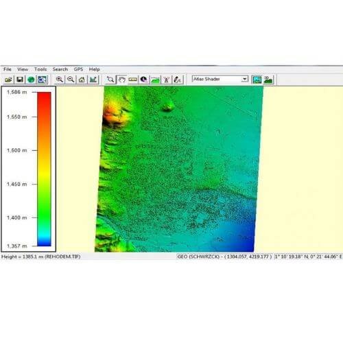
Lidar
Lidar, short for Light Detection and Ranging, is a remote sensing technology that uses laser light to measure distances and create detailed, three-dimensional maps of the surrounding environment. By emitting laser pulses and measuring the time it takes for the light to return after bouncing off objects, Lidar systems generate high-resolution point clouds that are widely used in applications such as autonomous vehicles, geospatial mapping, and environmental monitoring.

Discover the Advantages
High Accuracy
& Precision
Lidar systems can provide highly accurate and precise measurements. They can capture details with sub-centimeter accuracy, making them valuable in applications where precision is critical, such as surveying, mapping, and autonomous vehicle navigation.
3D Mapping and
Imaging
Lidar produces detailed three-dimensional maps of the environment, capturing the shape and
elevation of objects and terrain. This is especially useful in applications like urban planning, forestry management, and environmental monitoring.
Range
and Detection
Lidar has a longer range compared to many other sensing technologies. It can detect objects at long distances, making it suitable for applications like long-range surveillance, monitoring large areas, and identifying objects in various environments.
All-Weather
Operation
Lidar systems are capable of operating in various weather conditions, including rain and fog. Unlike some other sensor technologies, Lidar is less affected by adverse weather, ensuring reliable performance in challenging environments.
Fast Data
Acquisition
Lidar systems can quickly acquire large amounts of data in real-time. This is beneficial for applications that require rapid data collection, such as autonomous vehicles that need to constantly update their perception of the environment.
Versatility
Lidar can be used in a wide range of applications, including but not limited to autonomous vehicles, forestry, agriculture, archaeology, environmental monitoring, and infrastructure inspection. Its versatility makes it a valuable tool across multiple industries.
Object Recognition
and Classification
Lidar can provide detailed information about the shape and size of objects, aiding in the recognition and classification of various elements in the environment. This capability is crucial for applications like autonomous vehicles, where understanding the surroundings is essential for safe navigation.
Safety and
Security
Lidar enhances safety and security by providing accurate distance measurements and detecting obstacles. This is particularly important in applications such as collision avoidance systems for vehicles, surveillance, and monitoring critical infrastructure.
Reduced
Interference
Lidar operates based on laser light, which is less prone to interference from other environmental factors compared to some other sensing technologies. This makes Lidar a reliable choice in environments with potential interference, such as crowded urban areas.
Technological
Advancements
Ongoing advancements in Lidar technology, including increased efficiency and cost reduction, contribute to its wider adoption across various industries, making it more accessible for different applications.
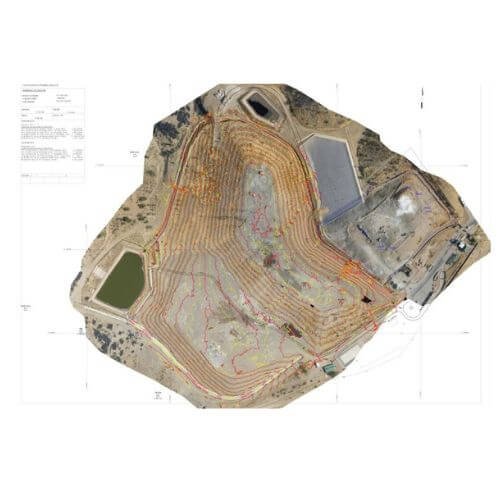
Topographic Surveys
Depending on image capture height, accuracy ranges from 2 cm to under 10 cm. An orthophoto, a geometrically corrected image with uniform scale, is produced. It aids in precise distance measurement. UAV/MAV with RTK GPS ensures highly accurate geographical data. These photos, compatible with software like ArcMap, ArcGIS, AutoCAD, etc., can be overlaid on CAD drawings for scale-correct background information.
Discover the Advantages
Accurate Terrain
Representation
Topographic surveys provide an accurate representation of the terrain, including elevation changes, natural features like hills and valleys, and man-made structures such as buildings and roads. This information is crucial for various engineering and construction projects.
Site Planning
and Design
Engineers and architects use topographic survey data for site planning and design. The detailed information about the land’s topography helps in making informed decisions about the placement of
structures, roads, utilities, and other infrastructure elements.
Volume
Calculations
Topographic surveys assist in calculating volumes of earthwork, which is essential for construction projects. This includes determining the amount of soil to be excavated or added to achieve the
desired grades and slopes.
Drainage
Analysis
Understanding the topography is critical for drainage planning. Topographic surveys help in analysing the natural flow of water, identifying potential drainage issues, and designing effective drainage systems to prevent flooding or erosion.
Environmental
Impact Assessment
When planning construction projects, especially in environmentally sensitive areas, topographic surveys help assess the potential impact on the natural surroundings. This information is crucial for obtaining regulatory approvals and ensuring compliance with environmental regulations.
Utilities
Planning
Topographic surveys provide information about the location of existing utilities and infrastructure. This is essential for planning new utility installations and avoiding conflicts with existing underground services.
GIS
Integration
Topographic survey data can be integrated with Geographic Information Systems (GIS) to create comprehensive spatial databases. This integration enhances the analysis and management of spatial information for a variety of applications.
Boundary
Determination
Topographic surveys often include boundary information, helping to accurately define the limits of a property. This is essential for legal and regulatory purposes, as well as for avoiding encroachments.
Land
Development
Developers use topographic surveys to assess the feasibility of land development projects. This includes understanding the terrain, identifying potential challenges, and planning the layout of structures and amenities.
Land Use
Planning
Topographic surveys contribute to effective land use planning by providing information about the suitability of different areas for specific uses. This is important for optimizing land resources and promoting sustainable development.
Derived Products from Processed Images
- Detailed topographic plan with all surveyed features required by client.
- An orthophoto which can be used as a back ground for the drawings and also to obtain additional scale correct information.
- A Point Cloud to be used for volume calculations (.csv).
- DEM(Digital Elevation Model) which is the same as a point cloud but reduced to a specified grid i.e. 10 m x 10 m.
- DWG/DXF
- TOT file (3D triangles)
- Other known formats such as .obj .3ds .wrl .dae .ply .stl .fbx .u3d .pdf and Google .kmz can also be exported.